 |
Ā Ā Ā Ā Ā |
|
Ā Ā Ā Ā Ā |
Ā |
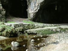
Smoo Cave lies at the inner end of a narrow inlet eroded into the Durness Limestone which is here lying almost horizontally. Smoo Cave contains a record of human occupation during several periods of historic and prehistoric time. The low soil-covered mound just inside the entrance was excavated in 1992 and proved to be a midden, that is, a domestic refuse heap. It was packed with shells, some of which can still be seen projecting up through the soil surface. The upper part of the midden was found to date from the Iron Age; deeper levels were progressively older. There is supporting evidence of a Mesolithic presence here, but it is only anecdotal. In 1972 Ian Keillor of Elgin spotted three probable Mesolithic implements, uncovered by erosion in the eastern bank of the burn. Unfortunately, he handed them over to a self-styled expert who took them away, supposedly for scientific testing. This person has not been heard of since. Ā |
||||||||||
Ā
In 1992 an archaeological dig on a midden site inside the cave unearthed many interesting finds. The upper layers were Iron Age in origin making this one of the most northerly habitation sites in the British mainland. The midden was packed with shells, some of which can still be seen today poking through the top soil. Deeper levels were progressively older and the deposits at the base are thought to belong to the Mesolithic Period, when the earliest human inhabitants arrived in the Highlands. Much earlier, in 1904, an excavation took place; but no formal report was published and the field notes cannot be traced. Donald Macdonald of Sangobeg followed the progress of the dig, and he has left on record his clear memory that several small bone pins were recovered. These would be fully consistent with a Mesolithic presence.Ā In 1996 excavation in the cave by Tony Pollard of Glasgow University Archaeological Division for Caithness And Sutherland Enterprise and Historic Scotland published a detailed reportĀ This is extracts form that report: Ā
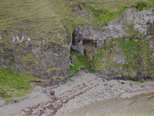
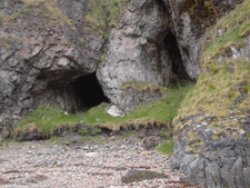
Ā The caves reported here may have, at some point in the distant past, existed as side chambers within the main cave now represented by Smoo Cave. With the land ward retreat of the main cavern these now exist as separate shelters opening out from the cliff walls of the Geodha. It is likely that further cave systems exist in the vicinity, with passages perhaps extending underground for some considerable distance. Indeed, work on the third of the sites discussed here brought to light a partially collapsed passage at the rear of the cave. The first two caves, Glassknapper's Cave and Antler Cave, are immediate neighbours, and are situated in the western wall of the Geodha. It was the presence of deep archaeological deposits visible in an eroding section face, which extends across the mouth of both caves which prompted the present work. These deposits rise up from the rear of the present beach to a height of around 1.5m, but at some time in the past the cave floor would have been at the same level as the beach as it appears today, and in fact probably lower. These caves, like the parent cave, appear to have undergone considerable collapse through time, with fragments of Limestone visible within the eroding deposits. The third of the caves to be discussed here (Wetweather Cave) is located in the eastern wall of the Geodha, where it curves to the southwest to meet the entrance of Smoo Cave. The cave is situated at the juncture of a grass-covered slope, which may itself represent cave roof collapse, and the present cliff face, around 10m above sea level. Ā For the purposes of site recording and in order to prevent future confusion with Smoo Cave it was decided to allocate each of the caves reported here with a name. The northern cave is henceforth referred to as the Antler Cave (AC), after the early finds of red deer antler. The southern cave was labeled Glassknapper's Cave (GKC) following the recovery of bottle glass, which appears to have been deliberately retouched. The presence of substantial fragments of rock in the various parts of the section indicated that the upper parts of both caves had suffered serious collapse at some point in the past. The caves may therefore have been considerably larger than they are now, a factor, which may have made them more fitting for human use than they appear today. Nevertheless, the presence of tractor batteries and boating equipment in the southern cave clearly indicates its use an equipment store in recent times. Having completed a survey of the cave interiors it became apparent that the most efficient means of fulfilling the objectives of the excavation would be to cut a single trench from the exposed section to the back of Glassknapper's Cave. The same would also be attempted for the Antler Cave, but priority was given to the first cave as this appeared to contain more complex archaeological deposits. The cave floor was divided into two, roughly along its central axis. By the time the excavation had been completed much of the southern half had been removed, while the northern portion remained intact, providing a full section through the cave deposits. Several sections were cut through the southern half of the cave, at right angles to the actual section, thus providing an in-sight into the nature of the stratigraphy in a north-south plane (across the cave interior) as well as in an east-west plane (cave mouth to cave interior). The deposits were excavated down onto the former beach surface, where the concreted nature of the gravels and health and safely considerations prevented further investigation.Ā Ā
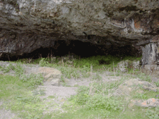
Wetweather CaveĀ One problem encountered during the project was caused by water, at various times either rain or melted snow, dripping from the roofs of the caves. At times the quantity of water made working within the caves very difficult, turning the deposits into a sticky dark mud, the problem being most acute in the Antler Cave where water was always present. In order to reduce the amount of time wasted due to wet conditions, which also made working within these caves dangerous, it was decided to carry out a smaller scale investigation in a further cave within the Geodha Smoo complex. The deposits in this third cave were nowhere near as deep as those in the other caves and its roof was relatively waterproof, hence its name, the Wetweather Cave. The Wetweather Cave was situated to the northeast of the mouth of the largest cave (Smoo Cave), where the foot of the cliff meets with a steeply rising grass covered slope. This cave differed in having a wide mouth, which gave way, for much of its width at least, to a head high over-hang, some 3-4m deep. As such the site would probably be described as an over-hang or rock-shelter in the earlier literature on cave archaeology. However to the rear of the overhang were at least two inner chambers, neither of which was examined. Ā
Conclusion and Discussion The excavation of the Geodha Smoo Caves resulted in the identification of complex archaeological deposits and the recovery of valuable artefactual and environmental evidence. Optimum preservation levels were encountered, with animal bones and organic artifacts plentiful in a number of deposits. The presence of archaeological deposits in the three caves described here and in Smoo Cave itself clearly indicate the importance of this coastal location in the past. Prehistoric activity is evidenced by the deposits in the Wetweather Cave but the majority of the evidence, from all of the other caves, indicates their use during the Norse period. Despite its confirmed occurrence in only one of the, caves (but see Pollard 1992), the discovery of prehistoric activity in the Wetweather Cave is of some considerable importance. Our present understanding of the extent and character of prehistoric, and indeed later, settlement in this extreme northwest corner of Scotland is limited, with very little fieldwork so far carried out in the area; a rare exception being Reld's survey of prehistoric monuments in the Dumess area (1967). The prehistoric utilisation of coastal caves and marine resources in the northern fringes of mainland Scotland should perhaps come as no surprise and the patterns of activity evidenced may bare some similarity to those envisaged for the west coast of Scotland (Pollard 1994). The evidence from the other caves clearly indicates that marine resources continued to play an important role in the historic period. The deposits within the Glassknapper's Cave strongly suggest that the Norse, in an area characterised by an exposed coastline regularly battered by heavy seas, regarded the Geodha Smoo as an important natural harbour. There is also place name evidence (Fraser 1995, 94) to suggest a Norse presence, with the name Smoo perhaps having its origins in the Norse Sm·ga (rift, cleft, cave).
In common with other northern Scottish sites, the presence of quantities of large fish bones in the Glassknapper's Cave suggests that deep sea fishing played an important role in the Norse economy. The importance of boats is further emphasis by the presence of rivets and metal slag, both of which indicate the repair of boats. It is difficult to say whether this activity merely represents one component of a more complex Norse archaeological landscape, with settlements situated in reasonably close proximity to the caves. If this were the case then the caves may relate to the daily practice of marine exploitation, representing the place at which fish were landed and processed before being transported to the settlement, balt (shellfĒsh?) prepared and boats maintained. However, as yet, no Norse settlements have been identified in this area, although the recovery of a Norse burial from the sand dunes at Balnakeil some 4 km to the northwest (Dorothy Low pers comm) does suggest that activity was not confined to the caves and their immediate environs. As with the case of prehistoric settlement, our under-standing of Norse actively along this part of the northern coast of mainland Scotland requires a more intensive programme of research. Excavations at Freswick Links and Robert's Haven have provided physical evidence for the Norse presence in Caithness suggested by a proliferation of Norse place names. More recently small scale excavation at Dunnet Bay, some 75km to the east of Smoo, has revealed the presence of a Norse settlement on the northern coast of Caithness (Pollard 1996). It remains to be seen whether this settlement pattern extends as far west as Smoo or whether the deposits in the caves were merely the results of temporary stop-over by Norse mariners on their voyages from Scandinavia and the Northern Isles to the Western Isles and more southerly destinations such as Ireland and the Isle of Man. In the absence of further evidence this latter hypothesis is an attractive one, with the sheltered Geodha and the caves providing the ideal location in which to carry out repairs on boats, which may have suffered damage in heavy seas, the beach allowing boats to be hauled ashore if necessary. This 'port in a storm' would also provide the opportunity to process fish caught on the voyage and to procure other foodstuffs, both wild and domestic, from the immediate environs of the caves. Although the deposits in both the GKC and AC were of considerable depth they may have resulted from regular visits, perhaps several times a year, and thus may have built up quite rapidly, perhaps over a period no longer than one or two hundred years. Despite the fact that much of the activity does appear to relate to Norse activity the potential for earlier (perhaps Iron Age) and later (Medieval and postĀ Medieval) phases of use should not be overlooked. It is hoped that radiocarbon dating will help to clarify these chronological issues. Only with the completion of a full post-excavation programmed will we begin to more fully understand the archaeological implications of the deposits reported here. However, in the meantime, it is hoped that this report has served to demonstrate the rich potential of these sites. Ā
|
|||||||||||
.gif)